Field of natural radioactivity of the Earth exists since the moment of creation of our planet. It is formed both by radionuclides appeared as a result of nuclear transformations during creation of solar system and did not decay for almost five billions years of existence of the Earth and by cosmic radiation. More than 60 natural radionuclides are observed in the biosphere of the Earth. The main radionuclides contributing into the human body burden are those related to uranium-radium and thorium series and potassium-40. Average content of uranium, thorium and potassium in the Earth crust equals 2.5*10--4%, 13.0*10-4% and 2.5% respectively. Each gram of potassium contains 119 micrograms of radioactive potassium-40. Variations in the content of these radionuclides in the surface layer of the Earth mainly depend on the types of geological material, depth of occurrence, soil formation processes and may significantly deviate from average values. Spatial distribution of uranium, characteristics of soils and climate having impact on the processes of gas exchange between soil and atmosphere determine the natural radioactivity of atmosphere. Mainly it is determined by radon-222 and its decay products. Radon-222 is an inert gas with half-life period 3.8 days and it is formed as a result of decay of radium-226. To the south of 55° of northern latitude concentration values of radon-222 in the air varies predominantly between 3.5-7.4 Bq/m3.
Cosmic radiation of galactic and solar origin consists mainly of high-energy protons. Earth's magnetic field and its atmosphere ensure reliable protection of human being and all living things from direct impact of these destructive fluxes. Secondary cosmic radiation in the field of which the inhabitants of the Earth live is formed as a result of interaction of primary cosmic fluxes with Earth’s atmosphere, in particular of respective nuclear reactions resulting in formation of radionuclides, mainly of tritium (hydrogen-3), berilium-7, carbon-14.
Anthropogenic sources of ionizing radiation appeared together with the natural ones since the beginning of utilization of nuclear energy. Significant global changes in radionuclide content of biosphere started from the middle of XX century due to extensive atmospheric tests of nuclear weapon carried out by nuclear states in 1950-1960s. During powerful nuclear explosions either on the earth or in the atmosphere the main part of radioactive fission products passed to stratosphere, more or less uniformly distributed there, stayed there for months and years and gradually fell on the surface of Earth. Since then short-lived radionuclides decayed and due to fallout of long-lived radionuclides – cesium-137, strontium-90, transuranium elements – global low background radioactive pollution of earth’s surface and aqueous medium have been formed. Maximal levels of soil contamination stipulated by global fallout are inherent to the region of Earth surface located between 40° and 60° of northern latitude. There is a close correlation between levels of global radioactive contamination and amounts of average annual atmospheric precipitation and it explaines somehow a non-uniform distribution of global pollution density.
Signing by nuclear states (except France and China) of Moscow Treaty Banning Nuclear Weapons Tests in the Atmosphere, in Outer Space, and Under Water put the end to accumulation of global discharges of long-lived radionuclides.
Underground tests of nuclear weapon and normal operation of nuclear and conventional power plants and nuclear fuel cycle facilities do not have significant impact on natural environment. Generally its additional contribution to anthropogenic background radiation has local character.
Radio-ecological status of the territory of Ukraine before the accident
Atlas contains the maps of global pollution of the territory
of Ukraine by cesium-137 and strontium-90. While drafting the maps of contamination
by cesium-137 and strontium-90 before the accident the data of regional radiological
service of the Ministry of Agrarian Policy have been used [9]. Monitoring of pollution
levels have been carried out at experimental grounds established in Ukraine
in 1970s. In each of impacted regions there were from one to five of these grounds
on the average. Average data regarding cesium-137 and strontium-90 for 1981-1985
have been used for preparation of pollution maps. Survey contamination maps
of the territory of Ukraine by cesium-137 and strontium-90 before the accident
-
![]() ,
,
![]() .
.
It should me mentioned that before the accident the territory of Ukraine has been quite uniformly contaminated by cesium-137 and strontium-90 of global origin. Insignificant exceeding of contamination levels in mountain area of Crimea and Carpathians can be explained by higher annual precipitation in these regions.
Contamination caused by Chornobyl catastrophe
For almost 40-years history of nuclear power industry there were several significant accidents at nuclear fuel cycle facilities and at nuclear reactors that caused off-site radioactive contamination. The best known of them are: at processing plant in Windscale (Great Britain) and at Kyshtym nuclear facility (USSR) in 1957, at Three Mile Island (USA) in 1979. During Three Mile Island accident 53% of fuel elements have been destroyed and almost 70% of nuclear reaction decay products moved to coolant. Meanwhile due to construction of protection facilities of reactor only insignificant part of radioactive substances has been discharged to environment [10, 11].
Fourth power unit of Chornobyl Nuclear Power Plant pertaining to second generation of nuclear power plants with reactors of RBMK type has been commissioned in December of 1983.
Chronology and causes of the accident at fourth power unit are described in special literature [12]. Explosion of reactor at 1:24 on the 26th of April of 1986 caused radioactive discharge of the reactor core fragments and steam-gas cloud saturated by the fuel debris of different dispersion, aerosol particles and radioactive gases.
Wide spectrum of forms and content of discharged radioactive products, change of efficient height of discharges, duration of discharges and their non-monotonic nature, change of meteorological conditions during the most intense emission caused formation of complex fields of radioactive contamination by radionuclides and detailed investigations of their structure are still an actual task. Structure of contamination fields of Chornobyl origin is non-uniform, spotted and oblong along the air fluxes lines. Among field structures the following structures are conditionally distinguished: Macrostructure determining the main tracks and spots; mesostructure reflecting field deviations in the framework of distinguished macrostructure peculiarities; local structures (coastline anomalies, waysides, drains etc.). Field macrostructure is determined first of all by meteorological factors – direction and speed of air-mass transport. Status of atmospheric boundary layer, presence of precipitation, landscape factors stipulate mesoscale structure – mosaic of the spots with high and low contamination levels.
There are three traces on the territory of Ukraine – western, north-eastern and southern – forming the macrostructure of the field. At the time of accident on the 26th of April, 1986 air masses near Chornobyl NPP were under the impact of the outer part of anticyclone. Within this area there were no significant changes of pressure between adjacent air masses. These conditions caused variable directions and low speed of winds. The latter did not exceed 2-3 m/sec at the air layer below 600 m. Mainly air-masses were transported to the west. On the 27th of April the pressure decreased and downpours were observed from time to time. Trajectory of the transport of discharge that occurred the day before continued to the west and north-west. Near Chornobyl NPP at 600 m height the direction of wind has been changed to the north with the speed 1-4 m/sec. Decreasing of pressure continued on 28th of April. At 100-700 m height the wind speed did not change. Wind direction changed from west to north-east due to low speed. Near-earth pressure decreasing has been continued also on the 29th of April. Wind speed in eastern direction in the near-earth layer increased to 6-16 m/sec. Wind direction on the 30th of April changed from north-east to south-west, and its speed slightly decreased. On the 1st of May wind speed increased to 10 m/sec in southern direction. On the 3rd of May there were still the winds in southern direction with registered storm winds up to 15-22 m/sec. Decreasing of wind speed to 6 m/sec in southern and south-western directions occurred on the 5th of May [12, 13]. General dynamics of discharge during this time span is presented on the fig. 1.1.
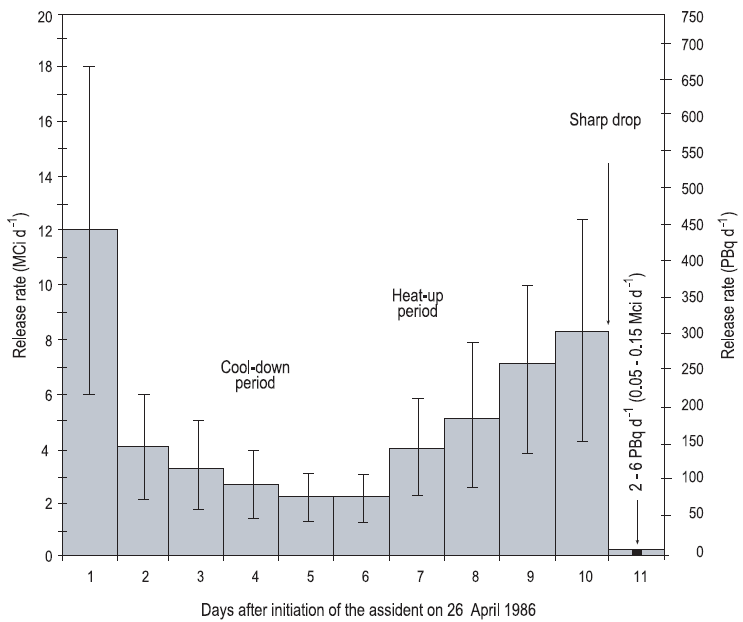
Figure 1.1 – Dynamics on daily discharge of radioactive material to atmosphere (with ± 50% deviation) [10, 14, 15]
Isotope content in the reactor core at the time of accident and assessments of total discharge by separate radionuclides are presented in the table 1.1.
В табл. 1.1 наведено ізотопний склад в активній зоні реактора на момент аварії та оцінки сумарного викиду окремих радіонуклідів.
Table 1.1 – Radionuclides accumulated in the reactor core by the time of accident and some estimations of total discharge of the most significant radionuclides during the accident at ChNPP [21]
|
|||||||||||||||||||||||||||||||||||||||||||||||||||||||||||||||||||||||||||||||||||||||||||||||||||||||||||||||||||||||||||||||||||||||||||||||||||
* Recently, there were estimations reduced amount of plutonium isotopes in the discharge by half [24, 25]
Differences in the contamination structure of certain territories by different radionuclides are determined by physicochemical properties of radioactive elements. Volatile elements (iodine-131, tellurium-132, cesium-134, -137) mainly passed from reactor as highly dispersed particles and aerosols and its formation had a condensation nature. Significant extent of contamination traces and presence of spots at long distances from reactor is typical for volatile elements. Released refractory elements (zirconium-95, molybdenum-99, cerium-141,-144, plutonium-238,-239,-240,-241, curium-242) passed from reactor in relatively big fuel particles, and its fallout occurred in the exclusion zone, on the territories adjacent to ChNPP.
Contamination by strontium isotopes has mixed nature and is mainly stipulated by fuel component of the discharge, but for the regions at the distances 150-300 km from ChNPP in the direction of southern trace, contribution of condensation components becames dominant, therefore contamination by strontium-90 has significantly spread beyond the exclusion zone. The highest levels of contamination by strontium-90 are observed along western (fuel) and within southern traces. In the latter case the particles in fallouts along the trace had both fuel and condensation origin.
During the active phase of discharges the nature of processes in the destroyed reactor has been changed and these changes determined the discharge height and intensity. Intensive “explosive” discharge on the 26th of April that has been spread within the near-earth layer formed the narrow “explosive” western trace. Radioactive inert gases (xenon-133 and other), volatile radionuclides (iodine-131, tellurium-132, cesium-134, -137) formed radioactive clouds at significant heights (up to several kilometers) and started its movement in western and north-western directions. Gradually the discharge output decreased to certain extent due to decreasing of temperature in reactor. But since the midday of the 27th of April reactor graphite started to burn more intensively causing new discharges, especially cesium-137. During this time span contamination of the territories both in western and south-western and northern and north-eastern directions has been formed (considering the changes of wind direction at different heights). At that time started the process of filling up of destroyed reactor. On 28-30th of April intensity and height of discharges significantly decreased. This stipulated relatively insignificant contamination levels in eastern and south-eastern directions. From the 2nd to 6th of May reheating of reactor occurred causing the increasing of discharge intensity practically up to the values of the first days of the accident. Formation of southern trace occurred during this time span. Due to increasing of fuel temperature the radionuclide content of discharges has been changed. Content of refractory elements has been increased as compared with more volatile cesium. After the 6th of May radionuclide’s discharges significantly decreased and later on stopped.
Atlas contains the maps of actual status of contamination of
Ukraine by cesium-137
![]() ,
,
![]() , strontium-90
, strontium-90
![]() ,
,
![]() ,
plutonium isotopes -238, -239, -240
,
plutonium isotopes -238, -239, -240
![]() and forecast of contamination by americium-241 in 2056
and forecast of contamination by americium-241 in 2056
![]() when concentration of americium-241 on the earth surface reaches the maximal
value due to decay of plutonium-241. Since the main inventory of Chornobyl fallout
activity is concentrated in the exclusion zone of Chornobyl NPP Atlas contains
the maps of contamination of exclusion zone and adjacent territories
when concentration of americium-241 on the earth surface reaches the maximal
value due to decay of plutonium-241. Since the main inventory of Chornobyl fallout
activity is concentrated in the exclusion zone of Chornobyl NPP Atlas contains
the maps of contamination of exclusion zone and adjacent territories
![]() ,
,
![]() ,
,
![]() ,
,
![]() ,
,
![]() ,
,
![]() ,
,
![]() .
Also the map-scheme of radwaste repositories in the close zone of ChNPP is presented.
This map shows locations of temporary localization of radioactive waste and
radioactive waste repositories
.
Also the map-scheme of radwaste repositories in the close zone of ChNPP is presented.
This map shows locations of temporary localization of radioactive waste and
radioactive waste repositories
![]() .
.
In preparation of the maps of contamination of the territory of Ukraine observation data have been used. These data have been obtained in the framework of the program of more precise definition of the radiological status of the territory of Ukraine after the accident at Chornobyl NPP carried out during 1986-1995 by radiological departments of different ministries and authorities (The State Committee of Ukraine for Hydrometeorology, the State Committee of Ukraine on Geology, Ministry of Agriculture of Ukraine, Ministry of Health of Ukraine, Academy of Medical Sciences, National Academy of Sciences and others). Apart of it the data of aerial gamma survey of the most contaminated regions of Ukrainian Polissya including woodlands have been used. Used sets of data are more complete as compared with the data used for preparation of contamination maps earlier [21, 22].
Several big settlements on the territory of Ukraine have been
significantly contaminated by radionuclides as a result of the accident: Prypiat,
Chornobyl, Korosten. Residents of Prypiat and Chornobyl have been evacuated
during the first days after the accident. Local spots with high contamination
level have been detected in the city Korosten after thorough survey. These spots
have been decontaminated. Relatively high levels of cesium-137 are still observed
in the northern part of Korosten. During construction of the Slavutych city
radiological situation on its territory has significantly improved. Only in
adjacent forests on the elevations contamination by cesium-137 is observed.
This contamination reaches 120-150 kBq/m2. The maps of contamination
of Korosten and Slavutych by cesium-137 -
![]() ,
,
![]() .
These maps have been prepared using the results of aerial gamma spectrometry
surveys carried out in 1994-1997 by aerial geophysical department of Production
Association “Pivnichukrgoeology” to order f the Ministry of Chornobyl (since
1996 - the Ministry of Emergency Situations of Ukraine).
.
These maps have been prepared using the results of aerial gamma spectrometry
surveys carried out in 1994-1997 by aerial geophysical department of Production
Association “Pivnichukrgoeology” to order f the Ministry of Chornobyl (since
1996 - the Ministry of Emergency Situations of Ukraine).
O.V. Gaidar, O.Ye. Lytvynenko, L.Ya.Tabachny